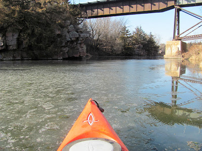
This blog is designed to highlight the paddling opportunities within South Dakota, mainly within a 50-mile radius of Sioux Falls. While Sioux Falls is far from the adventure of coastal regions, there is a certain satisfaction in utilizing the available waterways to observe weather, water conditions, and the landscape along the shoreline. In addition, there is a wealth of animal life on the waters of small South Dakota lakes, rivers, and creeks, including geese, ducks, pelicans, great blue heron, egrets, hawks, owls, perching birds, deer, raccoons, and beaver. Eagles, fox, and coyote are also sometimes spotted.

The sites described are places where I have kayaked over the past few years, mostly in South Dakota but sometimes including locations in Iowa and Minnesota. One of the best sources of information on the accessibility of small lakes is the South Dakota Atlas and Gazetteer, the large map book of South Dakota. Lakes with a public access are generally identified by a boat symbol marking the location of a launching site on public land.

You will notice the menu of paddling locations on the right side of the blog. Each of the postings is linked to one of the areas, and my intention is to provide a continuing review of the places where I paddle. Perhaps these narratives will help readers select waterways of interest to them. Please feel free to offer a comment regarding any of my postings; I would welcome the dialog.

I also maintain a companion blog that describes hiking opportunities within the Sioux Falls area. You can access that blog at: http://hikingsiouxfalls.blogspot.com

Monday, November 19, 2012

Split Rock Creek - Up Through the Palisades in Late Fall


 When Dave Finck went out to the Garretson City Park to check out the flow of Split Rock Creek upstream through the palisades last week, he found the surface ice covered.  It looked as though cruising on this especially scenic waterway was over for the season.

The last few days have seen a warm-up on the northern plains, so Dave and I arranged to meet at the put-in for this section of Split Rock Creek this morning.  It was 44 degrees when I arrived about 10:15 a.m., and the only ice we saw was on Devil’s Gulch, upstream into the shadows.

So, we launched our kayaks and proceeded north upstream on a beautiful sunny and nearly windless day.  It was a magnificent morning to be out on this slowly flowing body of water.  The water depth is down a foot or two, but that has little impact on kayaking.  For most of the trip upstream, the water was too deep to touch bottom, even with a double-bladed paddle thrust down to the maximum.

The sun on the east side of the creek cast the high quartzite formations in shadow across the water.  The landscape has become monochromatic in shades of brown as the winter approaches. The only sounds were birds up on the cliffs and in trees as well as a few squirrels rustling in the blanket of leaves covering the ground.  We saw a flock of wild turkeys up on the northern end of this waterway.  They were up on the floor of cliffs towering above us and then flew across the creek to land in the high brown grass on the western side of the creek.  The flock of perhaps 20 birds was visible both high on the cliff and standing around in the grasses of the shoreline. We also saw one deer dashing about on the eastern shore.

We continued upstream through the spectacular cliffs and rock formations until we reached the course of the creek coming down through the state park.

Our return trip downstream was slow, offering an opportunity to appreciate this unusual landscape of cliff faces and oddly shaped trees growing on ledges.  Even with the trees and grasses going into dormancy for the next several months, the play of light and shadow across the water was fascinating to observe.

As we returned to the put-in, we ducked through the arched bridge to see how far we could proceed up Devil’s Gulch through the ice. 

We found that there was a break in the ice along the northern shoreline, and we moved through this channel of nearly open water.  The ice formed just a couple of feet offshore and was perhaps a quarter of an inch thick at the edge, growing progressively thicker very quickly.

Dave was in front of me on the way in, and his kayak served as an icebreaker of sorts.  The ice was easily broken up for the first few couple of feet offshore, but the paddles just banged on ice just beyond that. 

We continued on until the ice blocked further passage.  By then, however, we were too far up to turn around.  The ice-free channel was only a couple of feet wide along the side of rock formations, and we had to back up 50 feet or so before finding a spot wide enough to turn around without going up on sheets of ice.


When we finished and drove through Garretson, the temperature had risen to about 53 degrees.  I don’t know if it will be possible to take another cruise this year; but, even if that should be the case, it was great to finish the season off with a great scenic cruise through the palisades of Split Rock Creek and then to cap it off with moving through an ice field.  

For anyone interested in the full set of photographs describing this cruise, please access my Flick account at the following URL:  http://www.flickr.com/photos/jayheath/sets/72157632049648877/

Wednesday, November 07, 2012

Late Fall on Lake Alvin


Dave Finck Heading South on Lake Alvin

Today was one of those glorious fall days here on the northern plains.  The morning temperature was in the high 30s, the sun was bright, and the winds were calm.  It was an ideal day to check out Lake Alvin as the natural environment begins to shift into the slower pace of winter and before ice forms on the lake.
Dave Finck
I loaded up my kayak and headed out to Lake Alvin, arriving at 10:00 a.m. in the public access area located on the southwestern end of this 100-acre lake.  Dave Finck had arrived at the lake an hour earlier, and he came down from the northern end of the lake just as I set out from shore.   We had miscommunicated our rendezvous time.
Entrance into Nine-Mile Creek
As nearly always, we headed first up into Nine-Mile Creek, which feeds into the lake from the south.  It was difficult to get past the shallow flats that have resulted from a receding shoreline, but we managed to grab hold of a bush and pull our kayaks around the bend and into a deeper channel heading into the flow of the creek.
Dave Finck in Nine Mile Creek
We proceeded upstream on Nine-Mile Creek for half a mile or so, keeping to a narrow channel of water that allowed easy passage – as long as we keep our eyes open for the deepest segment of the 30 foot wide creek.  As with rivers, low water tends to narrow the width of the waterway, but there is usually a remaining channel deep enough for canoes or kayaks.
Beaver Dam on Nine Mile Creek
After about half a mile, we came across a beaver dam that stretched across the creek.  This was the first time that I have seen a beaver dam on Nine-Mile Creek and was surprised. 
Beaver Dam on Nine Mile Creek
We were unable to approach closer than about 50 feet because of the shallow draft caused by an impoundment of water above the dam. I was disappointed in the limitation of our upstream cruise, but it was fascinating to see the beaver dam.
Dave Finck on Lake Alvin
Returning back downstream, we left the creek and re-entered the main body of the lake, keeping close to the shoreline as we moved north first along the east side and then over on the west side to the north end and the segment that curves east into a bay. I like keeping close to the shoreline so that I can peer into the trees and hills of the shore.  This is where I am most likely to spot any wildlife.  The range of colors and landscape along the shoreline are of great interest to me.  I don’t find cruising down the middle of the lake so compelling.
Jay Heath on Lake Alvin
We continued around the shoreline on the north end and entered into the spillwater channel.  The entrance into the channel is rocky, especially during this period of low water after such a long drought. 
Spillway on Lake Alvin
Still, once past the mouth of the channel, we were able to easily move up to the spillway itself and peer over the edge.
Spillway on Lake Alvin
Heading back to the south end, we came across a group of shorebirds standing around on a bare tree right on the shore.  At first, I thought that they were great blue heron, but on second thought, I am not so sure.
Waterfowl on Lake Alvin
This was a great way to spend a fall morning, especially a mid-week morning.  I was reminded of the benefit of retirement, a retirement that allows me the opportunity to go out on deserted lakes during “working hours.” My time on the water this morning was about two hours; of course, Dave Finck had another hour while waiting for me.
Look of Fall on Lake Alvin
I can’t help but wonder how many more times that I will be able to get out in my kayak or in a canoe this season.  Dave Finck told me this morning that today was his 68th time out on the water this year.  For me, I think that I have been out 29 times – about average for my cruising at this time of the year.  Perhaps I will get in one or two more times on area waterways before the kayak rack comes off the car and the equipment is put away for the next four months.

For those interested in the changing face of Lake Alvin, there are multiple narratives posted under the "Lake Alvin" link on the right side of the blog.  A complete list of the photos taken on this cruise can be found on my Flickr account at the following URL: http://www.flickr.com/photos/jayheath/sets/72157631955182990/