This blog is designed to highlight the paddling opportunities within South Dakota, mainly within a 50-mile radius of Sioux Falls. While Sioux Falls is far from the adventure of coastal regions, there is a certain satisfaction in utilizing the available waterways to observe weather, water conditions, and the landscape along the shoreline. In addition, there is a wealth of animal life on the waters of small South Dakota lakes, rivers, and creeks, including geese, ducks, pelicans, great blue heron, egrets, hawks, owls, perching birds, deer, raccoons, and beaver. Eagles, fox, and coyote are also sometimes spotted.

The sites described are places where I have kayaked over the past few years, mostly in South Dakota but sometimes including locations in Iowa and Minnesota. One of the best sources of information on the accessibility of small lakes is the South Dakota Atlas and Gazetteer, the large map book of South Dakota. Lakes with a public access are generally identified by a boat symbol marking the location of a launching site on public land.

You will notice the menu of paddling locations on the right side of the blog. Each of the postings is linked to one of the areas, and my intention is to provide a continuing review of the places where I paddle. Perhaps these narratives will help readers select waterways of interest to them. Please feel free to offer a comment regarding any of my postings; I would welcome the dialog.

I also maintain a companion blog that describes hiking opportunities within the Sioux Falls area. You can access that blog at: http://hikingsiouxfalls.blogspot.com

Showing posts with label Split Rock Creek. Show all posts

Friday, November 01, 2013

Split Rock Creek: Garretson City Park Through the Palisades


As we slip into November here on the Northern Plains, paddlers are either putting away their gear for the season or taking every opportunity for what may well be a final cruise of the year. As a retiree, I have some advantage over my working pals and can go out on a weekday during “working hours.”  As a matter of fact, I revel in that status!
Today seemed like the best day of the week for paddling, so 
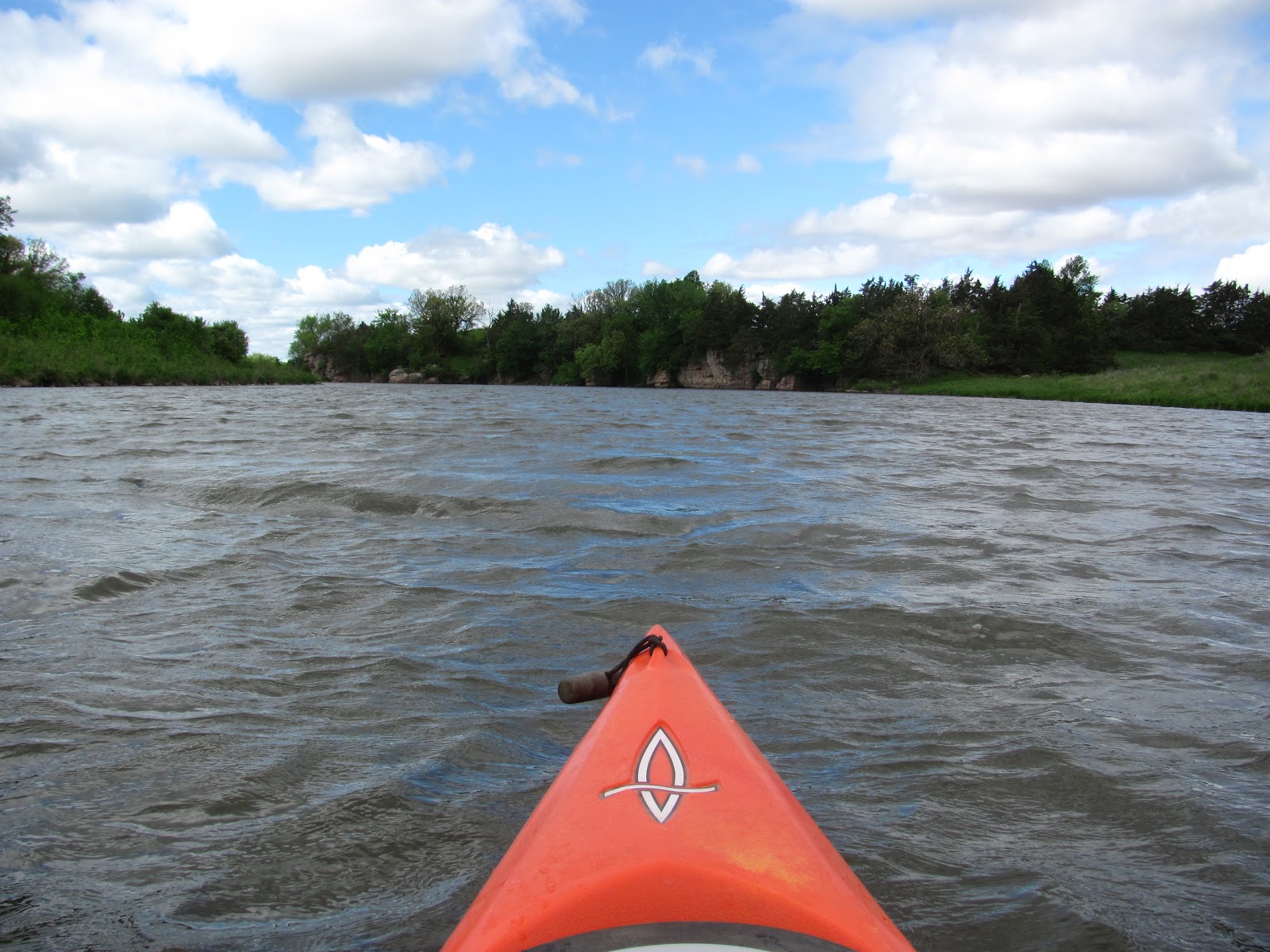
Dave Finck and I met at the city park in Garretson for a cruise up through the palisades.  This has come to be something I have done toward the final days or weeks of the paddling season for the past several years.
It was sunny, about 42 degrees, and quite windy as we arrived at the put-in.  The wind was blowing down through the canyon that forms the creek bed at about 25 miles per hour. 
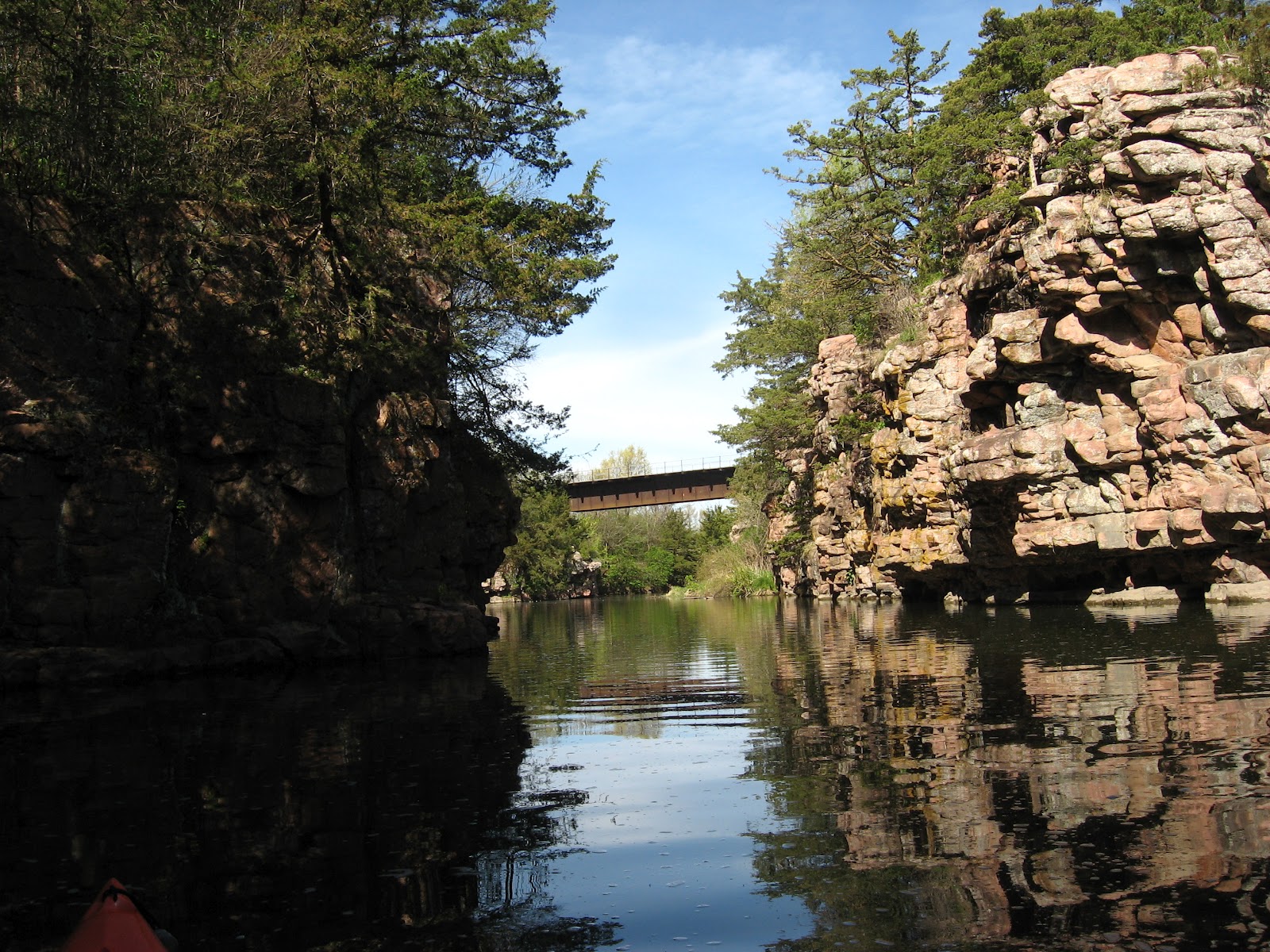
The high quartzite cliff walls that rise up along both banks tended to provide a lee along the cliff face and to reduce the force of the wind.  Still, we were paddling into a stiff head wind as we made our way upstream from the put-in just above the dam.
Paddling along this magnificent waterway, the seasonal shift into winter was evident.  Much of the leaf cover is gone and the grasses have turned brown.  There is little evidence of waterfowl now, although we did see a flock of robins that seemed to have delayed in their flight south.
The sun was bright over the cliffs, providing interesting shadows across the water.  I steered my kayak from cliff face to cliff face along alternating sides in order to experience the varying effects of sun and shade.
We made our way upstream to the riffles that lead into the impoundment formed by the dam within the park.  Some years ago, there was a single home located at this point, but now there is another large home visible from the creek. 
This is the point, about 1.25 miles upstream, where paddlers turn and head back downstream.  Along the way back, we came across a flock of 15 turkeys moving through the grass on the right bank.  They were spread out in a line that moved across the landscape into a grove of trees.
Along the return route, little paddling effort was required.  The wind just blew us back, and only an occasional paddle stroke was needed to track the course downstream.
As has become a feature of a Garretson cruise, we moved under the arched bridge and into Devil’s Gulch.  The wind here was also brisk, and it blew us up the waterway, past other sets of quartzite cliffs to the feeder stream flowing in from the woodlands.
We paused within the Gulch to view the changing landscape and then paddled back under the railroad bridge, through the arches, and into the main stream just above the “take-out.”
Our cruise this morning was for about an hour and fifteen minutes, and the distance was about three miles.  As we loaded up the kayaks, the wind was reported as 23 mph, and the temperature was in the mid 40s.  We had on jackets, boots, hats, and gloves this morning.  As usual, once we were off the water and trying to load up the kayaks, the cold seemed to intensify.  My fingers didn’t work all that well as I worked on the knots for the ropes that secure my kayak atop the car. 
This was a great weekday morning cruise, and I found myself enjoying the way the kayak cruised through the water.  We all know that there is little time remaining in this paddling season.  Still, I am expecting to get in at least a couple more cruises this year.
A full set of the photographs for the cruise this morning can be found on my Flicker page at the following URL:   http://www.flickr.com/photos/jayheath/sets/72157637201467723/

Friday, May 31, 2013

Split Rock Creek Above Garretson Dam


Yesterday, Dave Finck called and asked if I wanted to go out kayaking today, and I was quick to respond affirmatively.  We decided to go to Scott Lake, near Hartford.  As I got my gear ready this morning, I was a bit apprehensive about the wind conditions.  The day was described as “breezy” with winds 15-25 mph.  Still, we set out from Sioux Falls for Scott Lake at 8:00 a.m. and arrived there to find whitecaps over the lake.  Heading out into the waves and strong wind on that open lake did not seem like a good idea any longer, so we turned around and headed east to visit Split Rock Creek and cruise upstream from the dam at the Garretson City Park.

The wind was at least 25 mph blowing upstream from the dam.  Spray from the water flowing over the dam was blowing back upstream. 
But, along this sheltered waterway, the high palisades rising above the creek, the landscape of the creek bed, and the high banks decreased the concern for high winds.  Indeed, as we launched into the creek and headed upstream, the wind was at our backs and we were able to continue with very little effort upstream the 1.25 miles before reaching the rapids.
Winds may have well been above 25 mph as we made the cruise this morning, the temperature upon departure upstream was about 60 degrees, and the sky was an alternating series of dark and light clouds with occasional shafts of sun coming through.


The wind was strong enough to make photography difficult.  As I would fumble out the camera, wind would shift the kayak causing a lack of directional control.
We continued up into the palisades and enjoyed the new green of spring growth, the range of birds viewed, and the drift of clouds that produced alternating periods of deep overcast with relatively clear blue spots.
We ran into quite a number of wild turkeys this morning along the left bank going upstream.  They seemed to be roaming in the grasslands and did not seem especially startled to see us passing in kayaks.   There were many other birds as well, including a return of the cliff swallows that are already into their mud nests that adhere to the cliff walls of the palisades along the course of the creek.

The palisades are always spectacular along Split Rock Creek as they loom high overhead with their fantastic variety of plant growth sprouting from cracks in the surface and atop the summits.

Coming back, we ducked under the arched bridge that leads into the campgrounds of the park.  This entrance to Devil’s Gulch is secluded and nearly always calm.  The wind does not easily penetrate into the gulch. 

We moved under the railroad bridge until running out of a passageway.  This little oasis of tranquility is one of my favorite spaces along this waterway.  Bird life is abundant along the cliffs, and fish were swimming just under the surface as we crossed shallow spots.

After exiting under the arched bridge, we returned to the launching area and loaded up.  The cruise this morning took us about an hour and a half and was really a fine morning.

I gave written several narratives about Split Rock Creek through the palisades, and an interested reader can review these by accessing the menu of area waterways on the right side of the blog homepage.  For those interested in viewing the complete set of photos taken on the cruise this morning, my Flickr account is available for review at the following URL: http://www.flickr.com/photos/jayheath/sets/72157633837919310/

Monday, November 19, 2012

Split Rock Creek - Up Through the Palisades in Late Fall


 When Dave Finck went out to the Garretson City Park to check out the flow of Split Rock Creek upstream through the palisades last week, he found the surface ice covered.  It looked as though cruising on this especially scenic waterway was over for the season.

The last few days have seen a warm-up on the northern plains, so Dave and I arranged to meet at the put-in for this section of Split Rock Creek this morning.  It was 44 degrees when I arrived about 10:15 a.m., and the only ice we saw was on Devil’s Gulch, upstream into the shadows.

So, we launched our kayaks and proceeded north upstream on a beautiful sunny and nearly windless day.  It was a magnificent morning to be out on this slowly flowing body of water.  The water depth is down a foot or two, but that has little impact on kayaking.  For most of the trip upstream, the water was too deep to touch bottom, even with a double-bladed paddle thrust down to the maximum.

The sun on the east side of the creek cast the high quartzite formations in shadow across the water.  The landscape has become monochromatic in shades of brown as the winter approaches. The only sounds were birds up on the cliffs and in trees as well as a few squirrels rustling in the blanket of leaves covering the ground.  We saw a flock of wild turkeys up on the northern end of this waterway.  They were up on the floor of cliffs towering above us and then flew across the creek to land in the high brown grass on the western side of the creek.  The flock of perhaps 20 birds was visible both high on the cliff and standing around in the grasses of the shoreline. We also saw one deer dashing about on the eastern shore.

We continued upstream through the spectacular cliffs and rock formations until we reached the course of the creek coming down through the state park.

Our return trip downstream was slow, offering an opportunity to appreciate this unusual landscape of cliff faces and oddly shaped trees growing on ledges.  Even with the trees and grasses going into dormancy for the next several months, the play of light and shadow across the water was fascinating to observe.

As we returned to the put-in, we ducked through the arched bridge to see how far we could proceed up Devil’s Gulch through the ice. 

We found that there was a break in the ice along the northern shoreline, and we moved through this channel of nearly open water.  The ice formed just a couple of feet offshore and was perhaps a quarter of an inch thick at the edge, growing progressively thicker very quickly.

Dave was in front of me on the way in, and his kayak served as an icebreaker of sorts.  The ice was easily broken up for the first few couple of feet offshore, but the paddles just banged on ice just beyond that. 

We continued on until the ice blocked further passage.  By then, however, we were too far up to turn around.  The ice-free channel was only a couple of feet wide along the side of rock formations, and we had to back up 50 feet or so before finding a spot wide enough to turn around without going up on sheets of ice.


When we finished and drove through Garretson, the temperature had risen to about 53 degrees.  I don’t know if it will be possible to take another cruise this year; but, even if that should be the case, it was great to finish the season off with a great scenic cruise through the palisades of Split Rock Creek and then to cap it off with moving through an ice field.  

For anyone interested in the full set of photographs describing this cruise, please access my Flick account at the following URL:  http://www.flickr.com/photos/jayheath/sets/72157632049648877/

Tuesday, April 24, 2012

Split Rock Creek: Upstream from Garretson


This was a wonderful day, a day to relish being retired and able to operate on my own agenda!  After my routine bagel, two cups of coffee, and a good read at my favorite morning spot, I walked back home, fed the Finnegan the dog, and took off for Garretson for a paddle through the palisades. 

The Garretson City Park was developed in the 1930s as part of the WPA.  The project employed 47 men in the construction of a dam and the stone building that serves as the park headquarters.  The park is owned and maintained by the city and is really a fine place for a hike, camping, day use, fishing, and, of course, as a launching point for canoeing or kayaking upstream for a mile and a half or so.   This is also where the touring pontoon boat “Jesse James” departs.

As normal, I was alone in the park and on the water.  I set out and crossed to the other side to observe some geese paddling around.  As I approached the first set of palisades, I was surprised by a large goose flying out of the cliff wall.  I could not see how the goose managed to find a spot in the cliff, but it zoomed over my kayak so close that I could hear the wind turbulence of its passage.  I suppose that I spooked the goose causing it to flee my presence.  If I had been hit by that large goose, it would almost certainly have caused a capsize.

There were more geese on the water today than I have ever seen.  They were flying overhead, fleeing from the cliffs, on the water, and in gaggles in the grass along the shore.  I saw a pair waddling along through the grass with a group of goslings trailing behind.

A few turtles were out sunning themselves in the 70-degree sunny and windless day.

As always, though, the palisades are the dominant feature along this waterway.  I was cruising through about 9:30 a.m. so there were nice shadows cast on the water.  The spring vegetation has taken hold with a world of green emerging all over the landscape.  The green trees growing on top, in the cracks, and on ledges of the cliffs are spectacular. 
I just like to cruise alongside the cliffs and look up at the hardy plants that have taken hold on the cliff faces.  There are also lots of cave-like entrances into the cliff, although I think that they just extend a few feet.  Soon the cliff swallows will return and bring clouds of these birds around the palisades.  They live in mud waddle nests that are enclosed except for a conical entrance hole.

At times the palisades rise up along both sides of the waterway; and at other times, they alternate on sides of the creek. 

The creek can be navigated upstream for about 1.5 miles until reaching a set of rapids.  Essentially, this is where the backed up water from the dam ends, and the creek reverts back to its rocky course.  Two houses are located at this ending point on the impounded water.

On the way back, as usual, I ducked under the stone arched bridge to cruise into Devil’s Gulch. It is possible to paddle back a few hundred yards until running out of water depth.  High palisades line the banks of the gulch, just as along the main course of the creek. A high railroad trestle runs overhead crossing the gulch. There were even geese on these waters today.

My cruise this morning took about an hour and a half.  However, I lingered along the cliff faces, looked at the geese, and just cruised along at my slow but contemplative pace. As I cruised along, I noticed the contrails of jet aircraft crossing high overhead, bound for distant places.  The reflection of their contrails traveled along with me on the return cruise.

The last time I kayaked this waterway was in November on a cold moonlight cruise under the leadership of Dave Finck.  As I moved along the creek today, I thought about that cruise in the cold and dark and the challenge it represented. 

A cruise along Split Rock Creek upstream from the city park is one of my favorite outings for friends wishing to go kayaking.  I make the cruise about three times a year to enjoy the changing seasons along the shoreline.

Past cruises along this waterway can be reviewed through the narratives listed under Split Rock Creek in the inventory on the right side of the blog.  A complete set of the photographs associated with this cruise can be viewed on my Flickr page at: http://www.flickr.com/photos/jayheath/sets/72157629892366503/