This blog is designed to highlight the paddling opportunities within South Dakota, mainly within a 50-mile radius of Sioux Falls. While Sioux Falls is far from the adventure of coastal regions, there is a certain satisfaction in utilizing the available waterways to observe weather, water conditions, and the landscape along the shoreline. In addition, there is a wealth of animal life on the waters of small South Dakota lakes, rivers, and creeks, including geese, ducks, pelicans, great blue heron, egrets, hawks, owls, perching birds, deer, raccoons, and beaver. Eagles, fox, and coyote are also sometimes spotted.

The sites described are places where I have kayaked over the past few years, mostly in South Dakota but sometimes including locations in Iowa and Minnesota. One of the best sources of information on the accessibility of small lakes is the South Dakota Atlas and Gazetteer, the large map book of South Dakota. Lakes with a public access are generally identified by a boat symbol marking the location of a launching site on public land.

You will notice the menu of paddling locations on the right side of the blog. Each of the postings is linked to one of the areas, and my intention is to provide a continuing review of the places where I paddle. Perhaps these narratives will help readers select waterways of interest to them. Please feel free to offer a comment regarding any of my postings; I would welcome the dialog.

I also maintain a companion blog that describes hiking opportunities within the Sioux Falls area. You can access that blog at: http://hikingsiouxfalls.blogspot.com

Tuesday, August 28, 2012

Lake Alvin and Nine Mile Creek - Late Summer


Last night the forecast was for a calm day with a temperature in the 90s, and it seemed like a good day ahead for a cruise.  I loaded up my kayak in the late evening and got ready to depart home at 6:00 a.m. for my morning read and coffee. When I walked outside, though, I felt the first few raindrops and the sky was overcast.  Still, I was ready to depart, so I headed out.  I got to Lake Alvin by 8:30 a.m. and found myself in a thundershower with lightening flashing, thunder booming, and rain falling.  Rather than give up the cruise, I hung around for 30 minutes or so until the lightening and thunder passed and the clouds began lightening in the west and north.

Today, I decided to put in at the recreation area on the north shore and paddle south to Nine Mile Creek.  The lake surface ranged from flat calm in sheltered areas to small wind waves over more open waters.

I was curious to see the latest effects of the prolonged drought we have been experiencing here on the northern plains, especially in southeaster South Dakota.  The lake is full, and there did not seem to be any change in surface conditions.  The water was relatively clear, no algae was obvious on the surface, and the level seemed only slightly lower than normal.  The dock seemed to be elevated about six inches or so more than normal; it would have been difficult to clamor out of the kayak onto the dock with waters at this level.

The real test of how drought conditions are playing out in the Lake Alvin system, it seemed to me, would be to head up Nine Mile Creek.  People had told me that passage into the creek was not possible now; but, I wanted to see how far I might make it anyway.

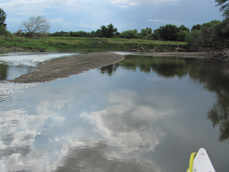
Heading down the lake to the south end, it is important to keep to the left bank, especially after passing the public access site on the southwest shore.  A sand bank or bar tends to develop at the mouth of Nine Mile Creek as it flows into Lake Alvin, and that condition was evident today. 

I kept to the left bank and still ran aground a few times.  In these situations, I remember what I think of as the “Pete Larson Clawing Technique.”  On a trip down Split Rock Creek a few years ago, we tended to frequently come across shallow gravel or sand bars across the waterway.  Rather than trying to pole through these shallows with the paddle, he demonstrated how you can just reach down into the water and claw your way along the bottom and ease through such shallows.  The act of clawing lifts the kayak bottom a little, and the grip through the sand or gravel propels the boat through into deeper water. I used this technique in passing over the bar leading into Nine Mile Creek today.

Once into the creek, the channel was deep enough to easily make my way upstream about two-thirds of my normal route.  Water depth tended to be 1.5 to 2.5 feet through the channel – plenty of depth for a kayak.  The narrower the course of the creek, the deeper the channel appeared.  Trouble developed mostly when the course became wider, although it was only necessary to back off a little and move over some to find the channel.

I came across lots of birds, including a great blue heron, but they generally flew off as I approached.  One duck seemed to lead me for a while through the channel.

As I neared the point where I usually have to turn back, I found it impossible to continue.  This was the first clear evidence of drought.  The flow of the creek had diminished to the point where the kayak would no longer clear the bottom.  I was able to easily turn back, again using the crawl, and move back downstream toward the lake.

After exiting Nine Mile Creek, I kept to the eastern shore and proceeded up the lake to the boat launch within the recreation area.

Mine was the only boat on the lake, and I only saw one guy fishing along the southwestern bank.  A couple of SDGFP guys were working on the road within the recreation area.  Otherwise, as normal on a weekday, I was along on the lake and in the park.

As I have often reflected, Lake Alvin is really a good spot for a cruise, especially a cruise that combines open lake and creek paddling.  Lake Alvin does not have any cabins along the shore, so it seems more secluded than some other popular lakes. It is a “wake free” waterway, so any other traffic would be slow moving fisherman or people in kayaks or canoes. But then, on weekday mornings, there are generally no other people about.

I’m glad that I waited out the passing storms and was able to enjoy a couple of hours paddling on Lake Alvin this morning.


Tuesday, August 14, 2012

Clear Lake (Minnehaha County) Cruise


Clear Lake is a large body of water in Minnehaha County about six miles southwest of Colton, SD, not to be confused with the city and lake southeast of Watertown.  The lake is a bit off the beaten path and accessible along 250th Street which passes through Baltic and continues west, south of Colton, until intersecting the lake.  The final mile of 250th Street becomes a barely maintained dirt and gravel road that narrows to a single lane as it runs along a slough. As usual, there are no signs offering information or even the name of the lake ahead.


The lake is listed by the SDGFP as 472 surface acres with a maximum depth of 11 feet. The name comes from times past when the water was very clear, and those conditions have changed markedly.  The SDGFP further describes the lake as “a shallow, natural lake located in northwestern Minnehaha County (that) is now heavily degraded and suffers numerous algae blooms and fish kills.  It receives its water from a relatively small local watershed and ground water.  Outflows exit down a small, unnamed creek to Skunk Creek and then the Big Sioux River.”


I have visited the lake once before several years ago to kayak with one of my sons, and I had a favorable impression of the landscape.  The dirt/gravel road approach, however, is as I remember it; meeting another vehicle would present a challenge for that last mile.


Dave Finck has visited Clear Lake many times over the past decades, and he expressed interest in going with me to revisit the site.  So, this morning he picked me up with his van and an aluminum canoe atop his boat trailer.   We set off from Sioux Falls at 9:00 a.m. and arrived at the primitive boat ramp about 9:45 about midway along the eastern side of the lake.


The lake was flat calm when we arrived, and we quickly unloaded his canoe and headed south along the eastern shore.  The lake is about two miles long on a north/south orientation and one and a-half miles wide at its southern end. The skies were overcast and the temperature was about 70 degrees: a nearly perfect day for kayaking.


The eastern side of the lake is wooded with some high embankments.  We cruised along the east side down to the southern end and then continued north along the west side.  The west side is largely farmed and presents a lower bank.  As we moved north, we encountered a mink out among the shoreline rocks.


The number and variety of shorebirds increased as we continued north; among these birds were great blue herons, egrets, gulls, and a variety of ducks.


Our arrival spooked flocks of shorebirds that sent me fumbling for my camera.  As it happens, the only camera I have available at the moment does not have an optical viewfinder, and I find it very difficult to locate and focus upon birds quickly.  This is especially difficult when I am engaging the telephoto function of the lens.


We reached the northern end of the lake and then began the return along the eastern shore.  By then, the wind had come up, and we were experiencing an increasing head wind.  Again, I thought of the need when visiting South Dakota lakes to go out on a calm day and then go early.  It was flat calm when we arrived; within just an hour and a-half, the wind had come up out of the south, producing six to eight inch waves.


I think that our cruise in a canoe was faster and less fatiguing than would have been the case using kayaks. It took us about two hours, including stops to observe the birdlife and landscape, to travel the seven miles or so of shoreline.


Clear Lake is an interesting body of water to visit.  The shoreline is varied, and there is an abundance of birdlife, especially shorebirds.  We were alone on the water; I would think that it would be rare to encounter another boater on this lake.  The SDGFP says that the greatest activity on the lake is ice fishing.  The launching site is fine for a canoe or kayak, although it would be difficult to put a larger boat into the water.  The boat ramp is in bad repair.  There is ample parking at the site.


Such a large body of water with only scattered shelter would be susceptible to a wind from most directions. I would think that marginal conditions on the water could quickly change to dangerous with the development of increasing winds. The water along the eastern side seemed deeper than along the western and northern, although there was plenty of depth all around the lake today. Dave Finck recalls a time in the past when the lake was markedly smaller than it is today.  The drought may have caused some recession of the shoreline, but the depth and overall extent of the lake seemed fine today, especially considering the dry summer this year.


So, the experience today suggests to me that an annual revisit to Clear Lake would be a good addition to my rotation of cruises.

For those interested in viewing the entire set of Clear Lake photos, please access my Flickr account at the following URL: http://www.flickr.com/photos/jayheath/sets/72157631070023594/detail/

Sunday, August 12, 2012

The James River and Assault by Asian Carp


Four years ago, the SDCKA organized a 12-mile cruise on the James River that began near Mitchell, SD, and that made the announcement of a cruise that took place yesterday especially attractive to me. Under the leadership of Dave Finck and Larry Braaten, this cruise was organized to put in at the Highway 44 bridge over the James River and continue 9.5 miles downstream to the Wolf Creek Hutterite Colony.

Six paddlers gathered at the truckstop near the Canton exit ramp from Interstate 29.  Five kayaks were loaded on the Finck trailer, and with Larry Braaten leading the way in his pickup, we headed west to the “put-in.”  Leaving Larry’s pick-up at the “take-out,” we all clamored into the Finck van and drove to the Highway 44 bridge over the James River, a few miles west of Freeman. 

There is no public access area defined for launching into the river at that point, but we just carried our kayaks and gear down the embankment and over a dried flood plain to an easy “put-in.”  Leaving the van parked off the road, we launched and set out downstream.

The James River, sometimes called the Longest Un-Navigable River, originates in North Dakota and flows 710 miles south to its confluence with the Missouri River near Yankton, SD. The river as it flows on the course of the cruise yesterday is about 100 feet wide, surprisingly deep, with a current that is virtually unnoticed.  As I checked the depth with my long double-blade paddle, I found that sometimes I could not reach the bottom.  I would guess that the depth within the channel ranged from four to seven feet. The landscape along our route included some low hills along one side or the other, but most of the area was pretty flat.  There were lots of dead trees along the banks, a result, I would guess, of flooding last year along the river. In addition, there were occasional submerged branches or tree trunks that were invisible because of the lack of current; I bumped over a couple of these and became centered on one in deep water for a couple of anxious moments. The course of the river on much of our route was serpentine.  While there was a stiff headwind at times, the constant twisting and turning of the river meant that the wind strength varied markedly along the route.

We passed by a couple of Hitterite colonies, and heavy earth moving equipment in operation left us in the dust for a while.  The operators of this equipment were the only people we saw along the route. We also passed a homemade boat that had been hauled up on the bank.

Shortly after we set out from under the Highway 44 bridge, we came under assault by dozens of Asian Silver Carp.  These fish were a constant concern as we made our way downstream.  These silvery fish with white bellies would leap out of the water several feet, often higher that a seated kayaker.  It seems that we must have spooked them with the passage of our kayaks.  They would appear by the dozens and bracket kayaks with their splash.  The scene of kayaks ahead reminded me of ships being bracketed by naval gunfire. One of our group twice had a carp land in his lap, and another member was struck in the shoulder.  All of us had plenty of near misses with the carp striking near our kayaks and showering us with water.  Some of these fish were 15-18 inches long and must have weighed two or more pounds.  It is hard to get an accurate measure of them since we didn’t catch any and our glimpse of them was fleeting.  We saw hundreds of them during our three and a-half hours on the river.  Anticipating the next eruption of jumping carp took the tranquility out of the cruise; we were all somewhat on edge with apprehension about being surprised and tipping over in the deep water and muddy banks.

I found a vivid you-tube video done by KELO about the Silver Carp lower on the James River that gives a good overview of the growing infestation and impact.  None of us on this trip had ever seen anything like this on any waterway.  The further spread of these Asian Carp is very troubling to anyone who uses the area streams and lakes.

We stopped about halfway through the cruise for a fifteen-minute break along the bank.  There were lots of mussels and many bones along the river.  One of the group saw a beaver, and we all saw large cave-like holes in the banks that seemed like dens of some sort. There were several great blue herons that flew along with us for a while, always flying ahead as we approached. 

With the imperceptible flow of the river, we were all continuously paddling.  The anxiety of anticipating the carp and long paddle left us all quite tired by the end.


We left the river just above a rocky ford at a public access area. After retrieving the van from the Highway 44 bridge, we loaded up the kayaks and headed for a late dinner together at the Pizza Ranch in Lennox. 

Even with the drought, the James River is in good shape for padding on the course we took yesterday.  The arrival of Asian Carp, however, takes the bloom off river paddling for now.  Perhaps some way will be found to deal with them, but there is also the potential of these fish growing in both size and numbers over the near term.  We all need to keep alert to developments in their spread and in possible ways to control them over time. 

For those interested in the full set of photographs of this cruise, please go to my Flickr account at the following URL: http://www.flickr.com/photos/jayheath/sets/72157631025942498/

Wednesday, August 08, 2012

Big Sioux River: Brandon-to-Brandon


Over the past weeks, I have watched the water level in the Big Sioux River diminish through the current drought.  As the river flows through Sioux Falls, much of the water bypasses the city through the diversion cannel located north of the airport.  Much of the flow through the city is from Skunk Creek as it enters the Big Sioux River off of Louise Avenue.

So, with the drought, I wondered what the river would look like as it moves south past Sioux Falls.  David Finck and I decided to take a short cruise on the Big Sioux River in what might be called the Brandon-to-Brandon stretch.  There is a public access area onto the river just off Rice Street, on the edge of Brandon, and the next “take-out” is at the Big Sioux Recreation Area, about 3.25 miles downstream.  This seemed like an ideal route to “test the waters.”

Today began with dark clouds and a teasingly short thunderstorm and rain.  By 9:30 a.m., the dark clouds had largely passed, and Dave and I met at the “put-in” off Rice Street in Brandon.  We shuttled his van and trailer down to the Recreation Area and came back in my Honda Civic.  We shoved off into the river about 10:00 a.m. or so.

The river has receded to a channel with wide sand bands and brush and tree remnants of past floods further narrowing the flow.

We decided to use an aluminum canoe of Dave’s for the cruise because of the anticipated shallows and the need to exit and reenter the boat multiple times.  We were surprised to find that this was not to be the case.  The river depth varied from four or five feet to only a few inches, but we were able to stay in the deeper channel most of the time.  We had to get out once to drag off a shallow sandbar and again to bypass a strainer that clogged the stream; generally, though, we were able to move smoothly down the river.

The landscape of the river is quite changed with the low water levels.  The normal water depth is a few feet higher than it is currently, and the driftwood and banks have taken on a definition that passes unnoticed during times of a swifter passage through a wider and deeper flow.

There were lots of birds visible as we cruised along, but they often flew off before I could fumble my camera out of its case.  We saw a large owl, a couple of great blue heron, and an America Bittern – at last a bird that stayed with us long enough for a photo.

The cruise was pleasant, a tranquil trip down the river in conditions that made such travel seem doubtful.  It was really a wonderful way to spend perhaps an hour and a-half moving along through interesting landscape.

Dave expressed the thought that perhaps kayaks would have not moved so easily down the river.  The canoe draws less water, and it is easier to get in and out of the craft while still on the water.  We lined the canoe through one set of strainers, exited the canoe twice, and once I got out and pulled it over a sandbar.  Getting in and out of canoes is an easier process to negotiate than in kayaks.

All too soon, we passed under the footbridge linking the two sides of the Big Sioux Recreation Area, and then came to the “take-out” just before the gravel road marking the end of the park. 

So, under the current dry conditions, it is still possible to travel down the Big Sioux River, at least on this “Brandon-to-Brandon” 3.25-mile section.  It was a great trip!

For those interested in the full set of photographs of this cruise, please access my Flickr account at the following URL:http://www.flickr.com/photos/jayheath/sets/72157630973893006/detail/