This blog is designed to highlight the paddling opportunities within South Dakota, mainly within a 50-mile radius of Sioux Falls. While Sioux Falls is far from the adventure of coastal regions, there is a certain satisfaction in utilizing the available waterways to observe weather, water conditions, and the landscape along the shoreline. In addition, there is a wealth of animal life on the waters of small South Dakota lakes, rivers, and creeks, including geese, ducks, pelicans, great blue heron, egrets, hawks, owls, perching birds, deer, raccoons, and beaver. Eagles, fox, and coyote are also sometimes spotted.

The sites described are places where I have kayaked over the past few years, mostly in South Dakota but sometimes including locations in Iowa and Minnesota. One of the best sources of information on the accessibility of small lakes is the South Dakota Atlas and Gazetteer, the large map book of South Dakota. Lakes with a public access are generally identified by a boat symbol marking the location of a launching site on public land.

You will notice the menu of paddling locations on the right side of the blog. Each of the postings is linked to one of the areas, and my intention is to provide a continuing review of the places where I paddle. Perhaps these narratives will help readers select waterways of interest to them. Please feel free to offer a comment regarding any of my postings; I would welcome the dialog.

I also maintain a companion blog that describes hiking opportunities within the Sioux Falls area. You can access that blog at: http://hikingsiouxfalls.blogspot.com

Friday, May 31, 2013

Split Rock Creek Above Garretson Dam


Yesterday, Dave Finck called and asked if I wanted to go out kayaking today, and I was quick to respond affirmatively.  We decided to go to Scott Lake, near Hartford.  As I got my gear ready this morning, I was a bit apprehensive about the wind conditions.  The day was described as “breezy” with winds 15-25 mph.  Still, we set out from Sioux Falls for Scott Lake at 8:00 a.m. and arrived there to find 
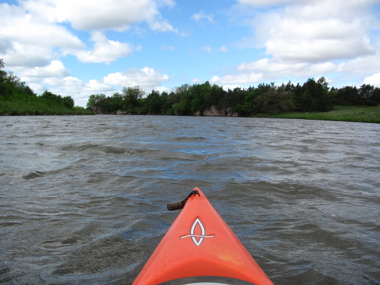
whitecaps over the lake.  Heading out into the waves and strong wind on that open lake did not seem like a good idea any longer, so we turned around and headed east to visit Split Rock Creek and cruise upstream from the dam at the Garretson City Park.

The wind was at least 25 mph blowing upstream from the dam.  Spray from the water flowing over the dam was blowing back upstream. 
But, along this sheltered waterway, the high palisades rising above the creek, the landscape of the creek bed, and the high banks decreased the concern for high winds.  Indeed, as we launched into the creek and headed upstream, the wind was at our backs and we were able to continue with very little effort upstream the 1.25 miles before reaching the rapids.
Winds may have well been above 25 mph as we made the cruise this morning, the temperature upon departure upstream was about 60 degrees, and the sky was an alternating series of dark and light clouds with occasional shafts of sun coming through.


The wind was strong enough to make photography difficult.  As I would fumble out the camera, wind would shift the kayak causing a lack of directional control.
We continued up into the palisades and enjoyed the new green of spring growth, the range of birds viewed, and the drift of clouds that produced alternating periods of deep overcast with relatively clear blue spots.
We ran into quite a number of wild turkeys this morning along the left bank going upstream.  They seemed to be roaming in the grasslands and did not seem especially startled to see us passing in kayaks.   There were many other birds as well, including a return of the cliff swallows that are already into their mud nests that adhere to the cliff walls of the palisades along the course of the creek.

The palisades are always spectacular along Split Rock Creek as they loom high overhead with their fantastic variety of plant growth sprouting from cracks in the surface and atop the summits.

Coming back, we ducked under the arched bridge that leads into the campgrounds of the park.  This entrance to Devil’s Gulch is secluded and nearly always calm.  The wind does not easily penetrate into the gulch. 

We moved under the railroad bridge until running out of a passageway.  This little oasis of tranquility is one of my favorite spaces along this waterway.  Bird life is abundant along the cliffs, and fish were swimming just under the surface as we crossed shallow spots.

After exiting under the arched bridge, we returned to the launching area and loaded up.  The cruise this morning took us about an hour and a half and was really a fine morning.

I gave written several narratives about Split Rock Creek through the palisades, and an interested reader can review these by accessing the menu of area waterways on the right side of the blog homepage.  For those interested in viewing the complete set of photos taken on the cruise this morning, my Flickr account is available for review at the following URL: http://www.flickr.com/photos/jayheath/sets/72157633837919310/

Saturday, May 25, 2013

The South Dakota Kayak Challenge - 2013


The third running of the South Dakota Kayak Challenge got underway this morning at 7:00 a.m.  The 72-mile race on the Missouri River began at Riverside Park in Yankton and concluded at Sioux City, Iowa.
The paddlers gather for the race at Riverside Park
Heading for the Beach
As I left Sioux Falls at 4:30 a.m. and headed south down I-29 to the Vermillion exit, the wind was out of the southeast and there was sheet lightening off in the distant south.  The sky was overcast, and the temperature was in the low 50s.  It did not look very promising for a 72-mile river cruise heading southeast from Yankton to Sioux City.
Boats Moving into Position
Pat Wellner getting ready to depart
By the time I arrived in Yankton about 6:00 a.m., the conditions had improved markedly.  While the sky was still overcast, the waters at Riverside Park were calm.  By 7:00 a.m., the skies had become partly cloudy and the sun was peeking out.  The temperature had climbed up to 61 degrees on the downtown bank thermometer by the time the fleet left.
Jarett Bies counting down the final minutes
Race Officials Conferring
SD Kayak Challenge officials included Jarett Bies, Steven Dahlmeier, and Cory Diedrich.  These leaders were supported by a large group of volunteers, many who have served in previous races.

The fleet was made up of 129 boats for the race this year.  The craft ranged from sleek surf-skis to short recreational boats and included both tandem and solo canoes and kayaks.

A Racing Tandem Canoe
Electronics and Hydrating Equipment
The VFW Provided an Honor Guard to Start the Race with a Rifle Volley
Some of the racers were within a competitive class, and they were serious athletes in excellent shape and usually equipped with sophisticated electronic equipment in their vessels to monitor location along the course and rate of speed. This class of paddler often also had a hydrating system to keep liquids flowing as they streaked along.
The Fleet About to Take Off from Riverside Park

Underway
Those paddlers who were in the competitive class were provided an opportunity to gather upstream of the departure beach so that they could have an “on-water” departure.  The bulk of the fleet left from the beach. 
Soon, the 129 boats were underway and heading downstream in a rapidly spreading group that quickly became differentiated. The sleekest boats and strongest paddlers moved into the lead as they made for the first checkpoint 18.4 miles downstream.

Most of the paddlers were in the race simply to participate and stretch themselves.  For most, just finishing the race was the objective.  Some of the boats were short recreational kayaks of just 10 to 12 feet.  While most were solo paddlers, there were also quite a few tandems, both twin cockpit kayaks and canoes. 


The first checkpoint for the race was Myron Grove, 18.4 miles downstream on the South Dakota side of the river. By 9:15 or so, the first boats were passing through CP #1. After the sendoff from Riverside Park, I headed to CP #1 and watched the first 25 boats pass through. Most of the paddlers just came by the dock, affirmed that their number had been noted, and cruised past for the next 12.1 mile segment to CP #2. Few of these lead paddlers came ashore at this point. There are a total of four checkpoints on the race before ending up at “Bev’s on the River” in Sioux City. 


Motorboats had been enlisted to serve as safety vessels along the route.  In addition, the Yankton/Vermillion Amateur Radio Club (Hams) members were providing communication services with their portable radios.


For additional information on the history of the SDKC, the following URL is recommended: http://sdkayakchallenge.org/about.htm. 


For those interested in viewing the complete set of photographs for this narrative, please go to my Flickr account at the following URL: http://www.flickr.com/photos/jayheath/sets/72157633700304976/

Saturday, May 11, 2013

Ethan Lake - May 2013


Yesterday after visiting Lake Hanson, Dave Finck and I took the short drive south down 421st Street to Highway 42 and continued west about seven miles to 413th Avenue until we reached the well-marked turn-off to Ethan Lake, just a couple of miles east of the small town of Ethan. 
Flatbed trailer used as a dock on Ethan Lake
Ethan Lake is described as being about 39 surface acres, having a maximum depth of 11 feet, and formed by impounding the flow from Twelve-Mile Creek.  The lake was developed in 1937 by the Works Progress Administration (WPA) and named after the nearby town of Ethan (http://gfp.sd.gov/fishing-boating/tacklebox/lake-surveys/southeast-lakes/docs/Ethan%202012.pdf).  While the lake is rather narrow, it extends northwest from the spillway for about a mile and a-half until reaching twin culverts passing under a road that feeds the creek waters into the lake.
Dave Finck in his Wenohan kevlar canoe
The “put-in” is on the southwestern end of the lake in a newly developed park.  We did not find a boat ramp, but putting in the canoe along the shoreline was easy.  There were two docks out into the water; one of them was new to me:  a flatbed trailer that must have been used behind a semi was just backed into the water.  That seems like a fast and efficient way to install a dock!
Heading north on Ethan Lake 
There are a few trees in the park area and a few along the spillway.  Otherwise, this is a pretty open body of water.  The lake continues northwest, gradually narrowing down as it approaches the inlet from Twelve-Mile Creek.
A great number of turtles seem to inhabit the lake, perhaps the most turtles I have seen in such a body of water.  Turtles seem to have enough visual ability to slide off rocks as soon as a canoe or kayak approaches.  We found some large flat rocks with a dozen turtles sunning themselves.  Then, there were some large turtles swimming just beneath the surface.  We also saw large carp moving through the shallow edge of the lake; they seemed to stir up the mud and then swim by us.  I didn’t see any jumping today. 
We passed one northern pike that was vertical in the water and seemed to be gasping for air.
Ethan Lake might be a good place for those with a keen interest in classic cars. 
There were several spots where old cars had been abandoned or dropped of along the bank.
Of course, there was no one else visible in the area. We were alone on the lake with just the birds, turtles, and fish.   The only development along Ethan Lake is the small park; there are no cabins and few trees.  The water depth is adequate, although there are some large rocks lurking just under the surface in some spots
The distance from Sioux Falls to Ethan Lake makes it outside the paddling circle for me.  Still, it is an interesting cruise, especially for someone interested in observing birdlife – or junked classic cars.
Inlet from Twelve-Mile Creek into north end of Ethan Lake
There are three lakes in this general area that I have visited over the past few years: Lake Dimock, Lake Hanson, and Ethan Lake.  Each of them has some unique quality and all are worthy of a cruise.  From Sioux Falls, all of them could be visited in one day; the cruise and lunch in one of the small towns would be a really fine outing!  Narratives for all three lakes can be accessed through the menu of area waterways located on the right side of this blog.
A complete set of the photographs for this cruise on Ethan Lake can be found on my Flickr account at the following URL: http://www.flickr.com/photos/jayheath/sets/72157633450012199/detail/

Friday, May 10, 2013

Lake Hanson - May 2013


Entering into North Shore Drive from 421st Street 
After several years of kayaking and canoeing area waterways, it is becoming increasingly difficult to find new bodies of water within the Sioux Falls area.  My general rule of thumb has been to never spend more time in the car traveling to and from a “put-in” than I do actually on the water.  But, in the search for new paddling opportunities, it has become necessary sometimes to travel further afar to a new lake, river, or creek.
Looking west down Lake Hanson from Highway
This morning, Dave Finck picked me up with his van, trailer, and one of his Kevlar Wenonah canoes for a ride west along I-90 toward Mitchell.  We turned off at Alexandria for a visit to Lake Hanson.  This little gem of a lake is just two miles south of Alexandria.  There is a newly resurfaced highway (421st Street) leading out of Alexandria two miles to North Shore Drive and a large sign announcing Lake Hanson on the right.
Launching site next to swimming beach
The lake is oriented east and west, and there is a developed area on the north side with lake homes, a beach, and a launching ramp. Pierre Creek flows into the lake from the east and exits at a spillway on the western end.  Lake Hanson is listed by the South Dakota Game, Fish, and Parks at 55 surface acres, which is about half the size of Lake Alvin.  The average depth is 8 feet, and the maximum depth is 17 feet. The lake extends about a mile from east to west and ranges from about 250 yards to 100 yards in width.  The lake was built by the Works Progress Administration (WPA) in 1934 and named by a local lake committee in honor of Hanson County (http://gfp.sd.gov/fishing-boating/tacklebox/lake-surveys/southeast-lakes/docs/Hanson%202012.pdf)
Looking west along south shore of Lake Hanson
We put in alongside the swimming beach in the Lake Hanson Recreation area on the north side of the lake.  There is another launching site further west along North Shore Drive. 
Nearing east end of Lake Hanson
From the put-in, we began a cruise along the shoreline, first to the dam and spillway and then along the south side for a mile or so to the culvert feeding Pierre Creek into the lake.  The south side is undeveloped and an easy cruise through deep water until reaching the eastern end.
Dave Finck in an "over the shoulder" photo from the bow
The day was really wonderful with little or no wind, sunny skies, and a temperature in the 60s.  We were alone on the water with just the turtles and birds. 
Heading west along the developed north shore of Lake Hanson
I think that this is a beautiful little lake, and living along the north shore would be a wonderful life.  The undeveloped sections of the lake provide good opportunity for bird watching and just enjoying life on the water.  We spend about an hour on the cruise this morning.
Along the south shore of Lake Hanson
As I looked at Pierre Creek entering into the lake from the east and then the spillway exit to the west, I was again amazed that such a minor creek can be impounded to create such a lake. These lakes that have been developed from flowing streams seem to retain their shape and depth even during times of drought.  Other lakes in the area that are natural but really more slough-like tend to dry up during periods of extended drought.
The spillway at the western end of Lake Hanson
The distance to Lake Hanson from Sioux Falls makes return visits for me unlikely. People who live in the Mitchell and Alexandria area, though, have a treasure for easy paddling and a pleasant cruise.
Pierre Creek feeding into Lake Hanson on east end
The set of photos of the cruise on Lake Hanson can be found at my Flicker site at the following URL: http://www.flickr.com/photos/jayheath/sets/72157633450046861/detail/