This blog is designed to highlight the paddling opportunities within South Dakota, mainly within a 50-mile radius of Sioux Falls. While Sioux Falls is far from the adventure of coastal regions, there is a certain satisfaction in utilizing the available waterways to observe weather, water conditions, and the landscape along the shoreline. In addition, there is a wealth of animal life on the waters of small South Dakota lakes, rivers, and creeks, including geese, ducks, pelicans, great blue heron, egrets, hawks, owls, perching birds, deer, raccoons, and beaver. Eagles, fox, and coyote are also sometimes spotted.

The sites described are places where I have kayaked over the past few years, mostly in South Dakota but sometimes including locations in Iowa and Minnesota. One of the best sources of information on the accessibility of small lakes is the South Dakota Atlas and Gazetteer, the large map book of South Dakota. Lakes with a public access are generally identified by a boat symbol marking the location of a launching site on public land.

You will notice the menu of paddling locations on the right side of the blog. Each of the postings is linked to one of the areas, and my intention is to provide a continuing review of the places where I paddle. Perhaps these narratives will help readers select waterways of interest to them. Please feel free to offer a comment regarding any of my postings; I would welcome the dialog.

I also maintain a companion blog that describes hiking opportunities within the Sioux Falls area. You can access that blog at: http://hikingsiouxfalls.blogspot.com

Thursday, June 27, 2013

Paddling in the Sioux Falls Area for People Without a Kayak


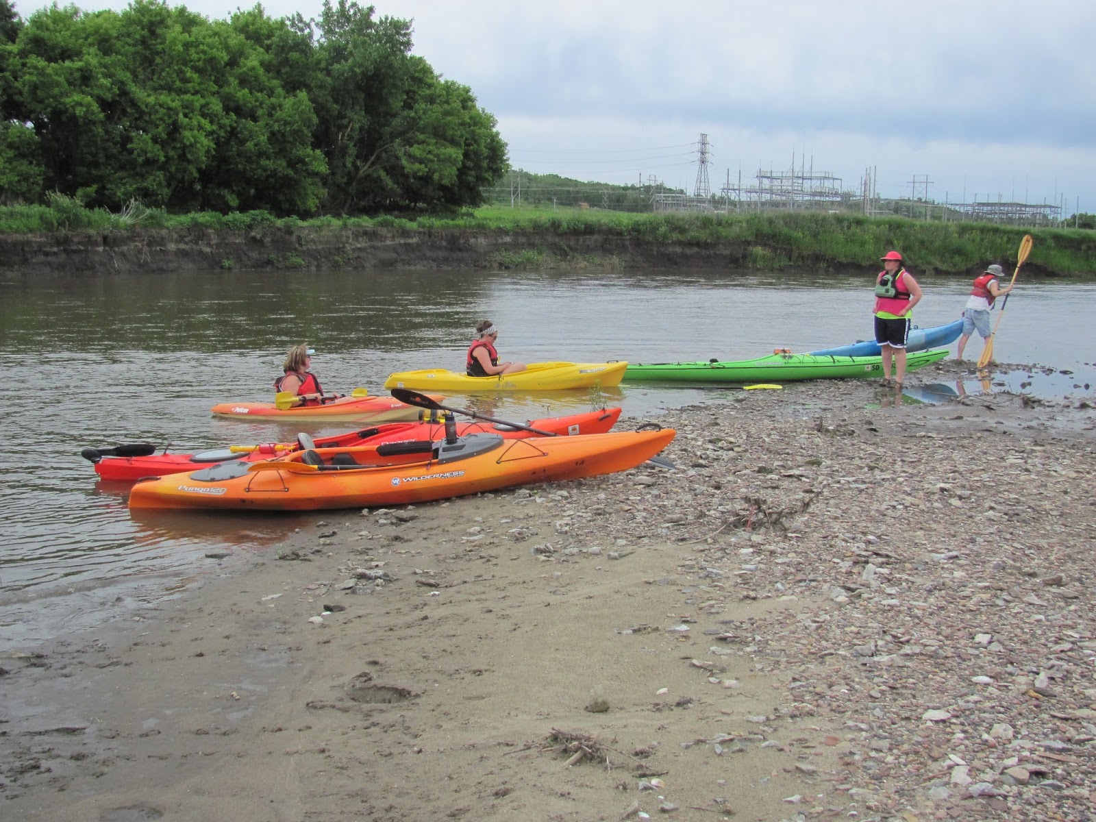
I recently became a volunteer with the Outdoor Campus, a South Dakota Department of Game, Fish, and Parks facility located in Sioux Falls, to work especially with paddling classes. My first assignment was to assist with a family paddling event that took place at Family Lake, west on 12th Street near the intersection of 12th Street and the Tea/Ellis Road.  The Outdoor Campus has about 16 single kayaks and a couple of tandem kayaks plus several canoes, and these craft were available for families to take out on the lake for nearly two hours of paddling.  Paddles and lifejackets were also provided by the Outdoor Campus.  This activity is free of any charge!

Some instruction was offered to those who were new to paddling, and I served as a safety coach out on the water to provide limited instruction, encouragement, and to be of assistance if needed.

This sort of activity is offered both for young people and for families on a regular basis.  One of the Outdoor Campus naturalists is in overall charge of these activities.  Although we were on Family Lake for this session, the paddling opportunities are more typically held at the large pond beyond the Outdoor Campus building at 4500 S. Oxbow Ave. in Sioux Falls.  There are sometimes river trips on the Big Sioux River as well.

I was quite impressed with this opportunity made available by the Department of Game, Fish, and Parks through the Outdoor Campus.  People have asked me how they might take their child kayaking or how they might try out the sport, even though they have no kayak.  I did not know about this service, but I want to pass along the information to those who would like to get out on the water but have no boat available.

So, if you want to take advantage of this opportunity, you might give the Outdoor Campus people a call at 605-362-2777 or contact them through their web site at the following URL: http://gfp.sd.gov/outdoor-learning/outdoor-campus/east/contacts.aspx


Wednesday, June 19, 2013

Pease Creek Recreation Area, Geddes SD, June 9-10, 2013


The following is a guest narrative from Patricia, a reader of this blog, who lives in Omaha and  paddles on the lakes of South Dakota.

I camped in the recreation area and was able to go paddling twice: Sunday evening and Monday morning.  Pease Creek is an inlet off Lake Francis Case, which is formed by the Missouri River behind the Fort Randall Dam.  There is a boat ramp that was used heavily by motorboats, but most must have headed out for the big water because I saw very few boats.
Sunday evening late I headed to the right from the ramp, following the east shoreline.  I heard lots of birds and crickets, but did not see many birds save for a bluejay and a goldfinch couple who followed me along the shore partway.  The most interesting sights for me were the fantastic figures formed by the bare dead trees and the interesting large rocks.  These last were both along the water's edge and in precarious positions in the tree roots.

The inlet eventually narrowed and began to meander, making a big S curve.  I wanted to keep going but the sun was below the bluffs on the west shore, so I knew my time was growing short. I finally turned back reluctantly, promising myself I would come straight back here in the morning.
I had a surprise coming back: there was a small island in the inlet, to the west, that I missed on the way out.  It blended in so well with the bluff behind it on my left that I didn't see it, since the setting sun caused me to look mostly to the right on the way out.
The last striking visual I had was the sun highlighting some tall bluffs where the inlet touches the lake.
Fast forward to the next morning when I was on the water by 6:30 am (this doesn't always happen).  There was only one boat trailer in the parking lot then; when I returned about 9:30, the lot was full.  Instead of taking in the scenery this time, I made a beeline to last night's turn around.  It took me about forty minutes to get back to that point; it took me only another two minutes to reach the end of the open water.  I had quit one bend short of where the rocks made the creek impassable.
I then proceeded back, hugging the west shoreline this time.  It was not as wooded or rocky, and I saw more birds flying about.  The structure of the bluffs was visible and a lesson in geology and plant life.
A solitary coot flew in and landed nearby, which I considered to be unusual behavior.  I usually see coots in large groups, and they are generally flying away from me.  My first thought was that Ernest Thompson Seton would have given this fellow a quaint descriptive name and written a story about how he came to be there by himself.
A large bay on the west had an interesting feature, tall dead trees with clumps of sticks lodged in their branches.  As I came closer, I noticed a heron perched on top and realized the sticks were probably nests.  I stopped approaching then, and backed up as quietly as I could because I didn't want to disturb any birds.  It was the closest I've ever gotten to a heron and very exciting.

I finished up following the west shore and cut across the inlet to return to the boat ramp.  The breeze was just beginning to pick up along with the boat traffic (all very nice and friendly), so it was a good time to head back, pack up the tent and drive home.  Mapquest claims that Pease Creek Recreation Area is two and a half hours from Sioux Falls; I wish it were that close to Omaha.

Monday, June 17, 2013

Lake Menno - late spring 2013

 In a continuing search for new paddling locations within the general Sioux Falls area, this morning Dave Finck and I set out in his van with a Kevlar Wenonah canoe lashed on top for a drive 68 miles from my eastside Sioux Falls home to Lake Menno.  The lake is just two miles west of the town of Menno set in the Furlong Creek valley.
The lake was formed as a WPA project in 1936 by constructing a dam across Furlong Creek.  The dam was destroyed during a flood in 1984 and rebuilt in 1995.  The lake covers 47 surface acres and is rated as a “no wake” body of water.  The size of Lake Menno is about half that of Lake Alvin.
There is a small park and campground on the site, a boat ramp, and a dock.  When we arrived this weekday morning, there was one camper in the area and no boats on the water nor fisherman on shore, although by the time we left someone arrived with a motor boat just to go for a trial run.
 
The lake is down in a valley with low hills surrounding it on the north and south sides.  Furlong Creek enters the lake from the northeast and exits at a spillway on the southwest side.  From the discoloration of rocks along the dam, it seemed to us that the water was down about three feet from a high water mark.
We departed from the dock and moved clockwise around the lake.  First we headed over to the spillway were we saw some cattle standing around in the water.  After greeting the cows, we moved over to the spillway and along the face of the dam and then down the north side.
The water is quite deep in most places in this lake.  In the area about 20 feet off the face of the dam, we measured about 34 feet of depth and over 8 feet of visibility with a secchi disk.  Two features of the lake are depth and clarity of water.
Another feature of the lake is an abundance of fish.  We paddled over schools of fish flashing about, more fish than I can recall seeing in other area lakes, although it may have appeared that way because of the depth of vision in this clear lake.

The most striking aspect of Lake Menno may be the trees and branches sticking up out of the deep water.  These tree trunks are sticking up about three feet above the surface and have he look of a flooded forest. 
We measured depths of up to 25 feet alongside some of the trunks.  It occurred to us that if the lake were up to the high water mark as indicated by the discoloration of rocks on the dam face, a motorboat could easy tear out its bottom by running over these large trunks lurking just at or below the surface.  
But in a canoe, we didn’t worry about it and just cruised through this vestige of a forest that had existed along the creek before the lake was created.
At the northeastern end of the lake, we entered into Furlong Creek and continued north for about three quarters of a mile.  The creek was about 50 feet wide as we began our trip upstream and it gradually narrowed as we moved north.
In the end, we decided to turn back when it became obvious that we would have to back down.  In the end, I got out of the canoe and pushed it through the reeds until we could turn around and return downstream.
Lake Menno is a fine little lake set in a beautiful setting.  We spent about an hour and a half paddling around the lake and up into the creek under sunny skies with a temperature in the low 80s and little wind.  It was a great day to realize that as retirees, both Dave and I could be out exploring lakes like this during “working hours.”

A complete set of photographs from this trip to Lake Menno can be found on my Flickr account at the following URL:  http://www.flickr.com/photos/jayheath/sets/72157634182609184/

Sunday, June 16, 2013

Big Sioux River: Lien Park (Sioux Falls) to Brandon


 This afternoon (Sunday), a fleet of ten kayaks under the leadership of Dave and Mary Finck and Larry Braaten made the cruise from Lien Park on North Cliff Avenue to the northern edge of the Big Sioux Recreation Area on the north side of Brandon – a distance of about nine miles.
 This segment of the river is frequently used by area kayakers for the cruise either to the first SDGFP launching site or on to another “take-out” three miles south at the end of the Big Sioux Recreation Area.
 Lien Park is not developed for recreation, especially for canoe/kayak launching.  A central feature of the site is the long haul from the parking lot, across the bike trail spur that terminates there, through the weeds, and down a steep slope to a difficult “put-in.”

I was able to use my wheels to roll my kayak across to the "put-in," and another person also had wheels.  Dave Finck has a special pass that allows him to drive over the grass to the river edge, and he used his trailer to move most of the boats.  Hauling my kayak over that distance would have left me groaning.
Today, the current was relatively fast and the slope dropped down into a muddy bank that led into deep water. So, the riskiest portion of the cruise was the launching of our kayaks.  Still, by assisting each other, all kayaks made it out into the stream without mishap.
After all kayaks were launched and grouped up, the cruise downstream got underway.  The day was really beautiful for a cruise.  When I left home, the temperature was in the 80s and the sun was bright over the landscape. After arranging our shuttle, the skies had darkened in the west and a light wind had developed, also out of the west.  We thought that rain might well develop.
Off we went down the river, generally keeping a fairly close group with kayaks always in sight of others.  The group might have sometimes spread out a quarter of a mile, but often also bunched up for some social chatter. On these cruises, there are always several conversational groups of kayakers that form and reform along the way.
There were no hazards that caused us any difficulty along the route.  There were old strainers that occasionally appeared, but there was always an easy passage past these old piles of trees.  The water depth was such that often I could not touch my double-blade paddle to the bottom.
About halfway along the route, we stopped on a sandbar to stretch out and poke around among the stones.  We came across a group of geese on this sandbar that moved off as we appeared.  Some people saw one or two deer along the shoreline, although I did not catch sight of one. 
We spent about three hours on the water today on this easy paddle.  The wind increased as we approached the final couple of miles, but the wind was at our backs.  With the current and the wind, it was possible at times to sail along with little effort.
As we approached the edge of Brandon, our fleet passed under the Rice Street Bridge and into the newly acquired northern extension of the Big Sioux Recreation Area.  A father and his two sons were fishing at the “take-out,” and the father lent a hand in pulling boats up through the mud onto a rough stone pathway up to the parking area.
This was a very pleasant Sunday afternoon cruise with no drama along the route – just the way I like it!  These river trips are always best with others along.  I am trying to keep to my advice offered to others:  don’t travel alone on moving water!
A complete set of photographs of this cruise down the Big Sioux can be found at my Flick account at the following URL:  http://www.flickr.com/photos/jayheath/sets/72157634161838419/

Thursday, June 13, 2013

Wetlands Clean-Up in Sioux Falls: June 2013


The South Dakota Canoe/Kayak Association has taken on the responsibility of cleaning up the wetlands at the canoe launching point along the Big Sioux River near the intersection of 26th Street and Southeastern Drive in Sioux Falls.  This means that at least twice a year SDCKA members gather to collect trash throughout this area for removal by the city.
 This evening six of us met in the parking lot at the launch site for our clean-up of the area.  We did a very thorough job last fall, and there was considerably less trash for us to gather this time.
 We roamed through the bush and tall grass and along the riverbank with our plastic bags and “grabbers” or pointed sticks. 
While we were there a kayak and canoe arrived from upstream around 57th Street and reported little debris in the stream, although they also said that one of the boats got hung up on the rocks but did not tip over in the rapids under the bridge over the bicycle trail.
So, this evening was one of the several public services performed by the SDCKA each year: the paddling fair, river clean-up, the wetlands clean-up, and water sampling from area lakes and streams.  
It was also a time to laugh it up with paddling companions and plan new trips for the coming days. 

Tuesday, June 11, 2013

The Klondike Dam Becomes the Klondike Rapids of the Big Sioux River


The Klondike Dam has now been fully transformed into the Klondike Rapids.  After kayaking on Lake Lakota yesterday morning, Dave Finck and I stopped by the Klondike Mill area to see the degree of change since our last visit earlier this spring.
There is nothing of the dam still visible at the site, and the water is flowing in great volume over the rapids formed by the rocks and the sculpting of the passage. 
People who love riding through turbulent water, laughing as they find their boat tossed about it the rapids, would probably like running the Klondike Rapids.  I sincerely doubt that I will ever attempt such a passage!
 There is now a rough portage on the South Dakota side of the Big Sioux that begins just above the rapids and passes about 300 yards up to the road and then down the trail to a put-in downstream from the bridge. 
Such a portage reminds me of traveling in the Boundary Waters Canoe Area of northern Minnesota.  It would be a long carry for a kayaker traveling solo, but not too tough if there are two people available. 
As I looked at the stream moving through the rapids, it seemed easier to consider “lining” a boat downstream from the Iowa side. 

At any rate, the old Klondike Dam has now become the Klondike Rapids.