This blog is designed to highlight the paddling opportunities within South Dakota, mainly within a 50-mile radius of Sioux Falls. While Sioux Falls is far from the adventure of coastal regions, there is a certain satisfaction in utilizing the available waterways to observe weather, water conditions, and the landscape along the shoreline. In addition, there is a wealth of animal life on the waters of small South Dakota lakes, rivers, and creeks, including geese, ducks, pelicans, great blue heron, egrets, hawks, owls, perching birds, deer, raccoons, and beaver. Eagles, fox, and coyote are also sometimes spotted.

The sites described are places where I have kayaked over the past few years, mostly in South Dakota but sometimes including locations in Iowa and Minnesota. One of the best sources of information on the accessibility of small lakes is the South Dakota Atlas and Gazetteer, the large map book of South Dakota. Lakes with a public access are generally identified by a boat symbol marking the location of a launching site on public land.

You will notice the menu of paddling locations on the right side of the blog. Each of the postings is linked to one of the areas, and my intention is to provide a continuing review of the places where I paddle. Perhaps these narratives will help readers select waterways of interest to them. Please feel free to offer a comment regarding any of my postings; I would welcome the dialog.

I also maintain a companion blog that describes hiking opportunities within the Sioux Falls area. You can access that blog at: http://hikingsiouxfalls.blogspot.com

Wednesday, October 25, 2006

Lake Alvin - Paddling Season Coming to a Close

Lake Alvin – the Paddling Season Closing Down

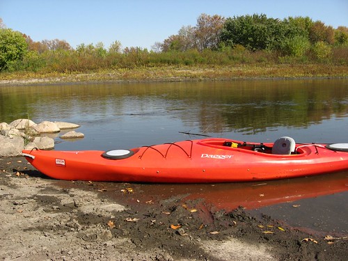
This was a beautiful fall day in late October, and I wanted to be sure and get in at least one last cruise before the onset of winter. I decided to head out to Lake Alvin, about 10 miles southeast of Sioux Falls, and see how the lake environment was changing as the season advances. I arrived about 10:00 a.m. to a deserted lake – no cars, no boats, no people about – and a temperature of about 40 degrees. The sun was bright on the water; there was a little breeze that created wind waves in the more exposed portion of the lake of about 4 inches or so. I stayed out for about two hours, and the temperature gradually rose into the 50s. I did not need a jacket nor were gloves necessary.

>IMG_0456

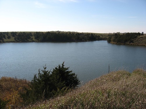
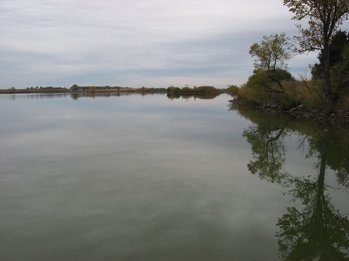
The docks are still in at both the State Park and at the public access area. More importantly, the water was higher than I had seen it all summer. I was able to paddle up into the outlet of the lake all the way to the spillway without touching bottom. I paddled around the total perimeter of the lake and then went up Nine Mile Creek until I reached the bridge over 479th Ave. This was the first time since last spring that I was able to make it up Nine Mile, and I could easily have continued even further. The water in the creek was consistently 3 to 4 feet deep. The water throughout the lake was clearer than it has been; I could see bottom easily up to about 2 ½ feet.

IMG_0446

During most of the cruise, there was little sign of wildlife; but, as I moved up into the southwestern part of the lake toward the mouth of Nine Mile Creek, I saw lots of waterfowl. I came across a large flock of geese – maybe 30 of them – and they remained stationary on the water as I allowed my kayak to drift along with the wind toward them. There were a couple groups of ducks behind the geese, and they were spooked by my presence and flew off. Later, the geese also took off in a group and moved east, away from me. At about the same point, I saw multiple large bullheads coming up to the surface of the water around my kayak.

IMG_0455

The cruise was pretty quiet. As I mentioned, there were no other boats. From time-to-time, there was some vehicle noise, but mostly the only sound was the wind moving through the dried leaves of large cottonwood trees.

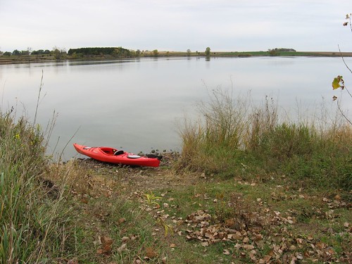
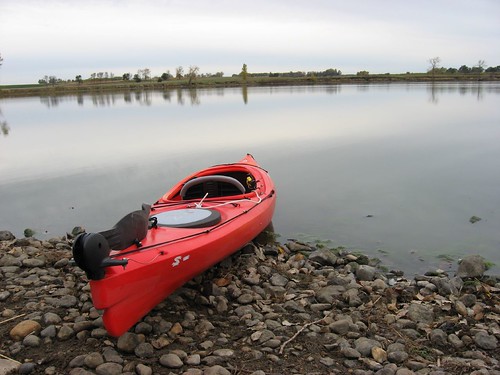
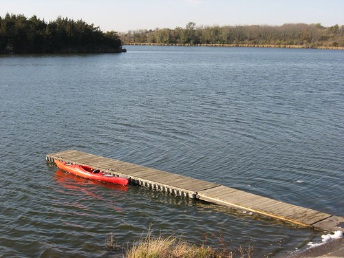
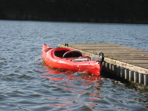
On this trip, I put in at the State Park and was able to enter and exit the kayak from the dock without getting my feet wet. The water was a little chilly, and I did not want to wade into the lake to get into the kayak. It all worked out pretty well, and I had a totally dry cruise around the lake.

IMG_0448

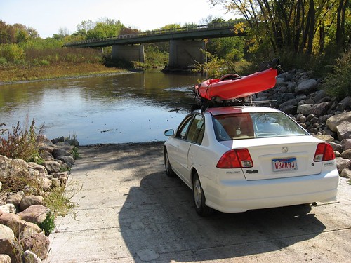
Normally, by this time of the year I have taken the Yakama rack off the top of my car. I have a Honda Civic Gas/Electric car, and the rack has a major effect upon my gas mileage. Normally, I get close to 50 mpg with the Hybrid, but with the rack affixed to the top of the car, the mileage drops down to about 38 mpg. I think that I will leave the rack on a bit longer this year. I am hoping to get in another cruise before the inevitable winter conditions arrive.

There are a couple of earlier descriptions of conditions on Lake Alvin in this blog. If you are interested in reading more about this very accessible body of water, just look at some of the earlier entries. .

Saturday, October 14, 2006

Split Rock Creek to Big Sioux

Split Rock Creek to Big Sioux River Bridge Over Highway 42


The South Dakota Canoe Association sponsored a cruise today that began at McHardy Park in Brandon along Split Rock Creek and ended at the Highway 42 bridge over the Big Sioux River at the developing Arboretum to the east of the Perry Nature Center and across from Arrowhead Park at the eastern edge of Sioux Falls. Gene Preston of the SDCA organized and led the cruise, and there were four canoes and four kayaks that made up the fleet. One of the advantages of going on a SDCA sponsored cruise, of course, is the shuttle arrangements from the "take out" point back to the "put in." Gene made those arrangements and that made the trip so much easier for all.

IMG_0435

The water was down a bit along Split Rock Creek, so the canoes put in at a point downstream. The kayaks, however, put in at McHardy Park along a sand beach. I took my older Dagger Bayou 10.5 foot kayak on the trip. Even though the kayaks bumped along on some rocks and scooted through some shallows, none of us had to get out of the boats during the trip. Split Rock Creek meanders along out of Brandon, past the race track, and through a variety of landforms and water conditions. There were a number of riffles to pass through, and occasionally some light rapids. The land was typical for prairie streams, low and high banks alternating and lots of old cottonwood trees. There was a good bit of bird life to observe, but the socializing aspect of a group cruise tends to warn wildlife off. Split Rock Creek passes the confluence of Beaver Creek and then the Big Sioux River. The passage becomes easier as each confluence is passed – more water, deeper passages, and fewer riffles.

IMG_0436

The cruise for the kayaks took about three hours, with pretty steady movement. We did not stop for strolls along the sand and gravel bars. The road distance between the park in Brandon and the bridge at Highway 42 is about 6 miles. I would guess that the river mileage is more in the range of 10 miles. The temperature was about 50 degrees, it was sunny, and the breeze was light. Since none of the kayak paddlers had to get out into the water, it was a really great cruise.

IMG_0437

This was a new waterway for me, although it has been frequently paddled. The SDCA has done this trip each year for some time. I am so glad to know about this paddling opportunity; I want to go on it next summer and
recreate the trip next fall as well. It is a wonderful half-day paddle.

IMG_0438

I had considered selling my older Dagger kayak because I bought a newer one this summer with additional features. This trip showed me, however, how useful it is to have a smaller and sturdy kayak for use in rocky rivers. All the kayaks were able to slide through and over rocks, and none of us were worried about damaging the boats. I would not want to take my Folbot or a handcrafted kayak down a waterway such as Split Rock Creek. So, I will just hang onto the old Dagger and use it for rougher waters. It has served me well.

Tuesday, October 10, 2006

Back to Grass Lake

Back to Grass Lake

This morning I decided to take advantage of a relatively nice day before the arrival of considerably colder weather. I left our eastside Sioux Falls home and drove out to Grass Lake, along 459th Ave, north of Highway 42 – about ten miles west of the city. I have described past paddles on Grass Lake earlier in the blog, and you might want to review that material along with my observations from today.

IMG_0430

The lake was mirror calm and the temperature was probably about 45 degrees. I arrived at the launching point about 9:00 a.m., got the kayak off the car, put on my water sandals, and moved off into the lake. The lake was deserted, as normal for that body of water.

I set off down toward the west end of the lake, past the larger island, and began to encounter lots of waterfowl. The first birds I saw were great blue heron, and then there were lots of gulls flying about. Geese in great numbers were on the water and flying over the area. There were also a few ducks to be seen. I was happy to see that the pelicans had not left the lake yet. I first came across a small flock of about eight pelicans; then, as I continued down the western end of the lake, I came to the spot where I normally see pelicans in large numbers on a shelving gravel peninsular. On this trip, I saw an additional 30-40 more pelicans in a large group in the shallow water off the peninsular. The geese seemed skittish and flew off as I approached; the pelicans, however, seemed calmer and remained in place watching as I passed them in my kayak.

IMG_0426

Along the way, I saw a beaver and a skunk, both moving away from me as I approached. On the south side of the lake, however, I came across a brown ferret moving along the water’s edge. The ferret seemed fearless. I stopped the kayak and moved along the shore to be close – less than ten feet. The ferret stayed in place and climbed up on a rock, stood on his hind legs and gave me a close examination. We looked at and followed each other along for about five minutes. To me, it was a real privilege to get so close to the ferret and share a mutual observation. The experience was much like the one I had with the family of raccoons as described in my earlier post of Grass Lake.

I continued kayaking for nearly an hour and a-half. By the time I made my way back to the “put-in,” my feet were pretty cold. I was wearing only the water sandals, and I had to wade in to launch the kayak. After I got the kayak back on top of the car and took off, I turned on the heater of my car for the first time this year. I need to look into finding some type of water shoes that might serve me better as the cold descends over the area.

IMG_0429

Again, you can add these observations to my earlier posting on Grass Lake. It still is one of my favorite small lakes in the area. As I reached Highway 42 for the turn east back to Sioux Falls, I saw a real estate sign with a “for sale” notice for two sites “on the water” two miles north – it has to be Grass Lake. I suppose that it is only a matter of time before people begin constructing lake homes on this body of water, much as happened to so many other lakes. The only public area on the lake seems to be the boat access spot owned by the Dept. of Game, Fish, and Parks.

Tuesday, October 03, 2006

Big Sioux River

Big Sioux River - Near Lake Alvin

Unexpectedly late this morning, I found that I had a free day. It was beautiful outside with temperatures in the low 80s, clear skies, and a light wind – just a great fall day. So, I decided to take one of my kayaks out on the Big Sioux River. I put in at a spot near Lake Alvin – about 10 miles south of Sioux Falls. A route from Sioux Falls would take you south on State Highway 11 going toward Lake Alvin. You can turn left off Highway 11 at 269th Street, just past the Lincoln County Line and go east to 480th Ave., parallel to Highway 11. Continuing south, you would turn east (left) onto 272nd Street at the sign to Larchwood. That paved road leads down a hill to a bridge over the Big Sioux River. There is a gravel road off the left that comes up suddenly and takes you down into a large graveled parking lot with a cement boat ramp. There is no sign off the road to this area, although there is a “public access” sign in the parking lot itself. It seems as though spots like this are cleverly obscured to ensure limited usage by those without some special knowledge of the area.


IMG_0417

The launching point is just upstream of the highway bridge, and it is not difficult to put a kayak into the water here. Like most river spots, there is a bit of black mud on the bottom, and it is difficult to get the boat in the water without stepping in a few inches of mud. I use a pair of water sandals that I can just hose off when I get home.

I set out from the launching point about 1:00 p.m., and it was very sunny and warm. Before leaving home with my gear, I set out a frozen bottle of water to take along with me for a few sips now and then. Unfortunately, in my rush to take off, I left the bottle on the table. Since I remembered the water only when I arrived at the river, it was something that came to mind often during the paddle.


IMG_0419

I kayaked up-stream, headed north on the river. The current was strong, but I was able to still move pretty easily up the river. Even at this point in early October, there was plenty of water in the river; the hull of my kayak did not go aground at all during the trip, although the rudder and my paddle blades scrapped bottom a few times when I strayed out of the channel. . From the launch point, I continued north on the river for an hour and ten minutes. The fall colors were vivid: shades of green, yellow, orange, and red. Some trees had lost all their leaves, while others were still full of green leaves. A wind blew through the big cottonwood trees rustling the remaining leaves. The river flows between alternating high and low banks. The high banks range from seven or eight feet to perhaps a hundred feet in height. The water depth is nearly always greater along the high banks.

About halfway through my afternoon paddle, I came across the ruins of a discontinued road and bridge - or maybe an abandoned railroad bridge. No trace of the actual bridge remains, but there are four large supporting structures in the river that supported the vanished bridge and a row of wooden stanchions that look like old telephone poles. Two of the supports are quartzite and the two middle supports are concrete. A dense log jam has developed at this point, and I had to make my way through about a ten foot gap in the debris between the two concrete supports. As always, the current quickens whenever the river narrows, and this is the only tricky spot that I found on the trip of about three miles up-stream.

The only wildlife that I observed on this stretch of the river was birds. There were three great blue heron that seemed to keep ahead of me along the entire stretch. They would fly off as I approached only to wait for me around the next bend. In addition to cormorants, there were a few other large birds that seemed like hawks in sight from time-to-time. With the regular erosion along the river, there are large tree trunks occasionally in the water as well.

This was the first time on the river that I have used a kayak equipped with a rudder, and I though that it made a great difference to my navigation, especially moving up-stream.. Normally in moving water, a kayaker has to double up on strokes along one side in order to keep a steady track in the river. With the rudder, I was able to just adjust to the effect of various currents by simply stepping on the rudder pedal, and that both increased my speed and made it possible to observe more of the shoreline and river conditions rather than fighting the current. On the way back down the river, it was just a matter of taking occasional strokes and keeping my place with rudder movements. On a kayak, the rudder has a “kick up” action that activates when the rudder strikes the bottom or some obstruction in the river.


So, while I prefer taking my kayak into lakes so that I can more closely observe the shoreline and look for wildlife or vegetation, the river is a good change of pace. It would be nice to have someone just drop you off at some point along the river and then meet you some miles downstream, but I usually have to manage my outings alone. In this case, the hard work of paddling up-stream for an hour or more is rewarded with a lazy return, just cruising along with little effort. There are many stretches of the Big Sioux that are easily accessed. The SD Department of Game, Fish, and Parks has published a pamphlet entitled “Canoeing and Kayaking in South Dakota” and a good map of the Big Sioux River. These publications would be especially helpful in arranging a shuttle or planning a trip along the river.