Big Sioux River - Near Lake Alvin
Unexpectedly late this morning, I found that I had a free day. It was beautiful outside with temperatures in the low 80s, clear skies, and a light wind – just a great fall day. So, I decided to take one of my kayaks out on the Big Sioux River. I put in at a spot near Lake Alvin – about 10 miles south of Sioux Falls. A route from Sioux Falls would take you south on State Highway 11 going toward Lake Alvin. You can turn left off Highway 11 at 269th Street, just past the Lincoln County Line and go east to 480th Ave., parallel to Highway 11. Continuing south, you would turn east (left) onto 272nd Street at the sign to Larchwood. That paved road leads down a hill to a bridge over the Big Sioux River. There is a gravel road off the left that comes up suddenly and takes you down into a large graveled parking lot with a cement boat ramp. There is no sign off the road to this area, although there is a “public access” sign in the parking lot itself. It seems as though spots like this are cleverly obscured to ensure limited usage by those without some special knowledge of the area.
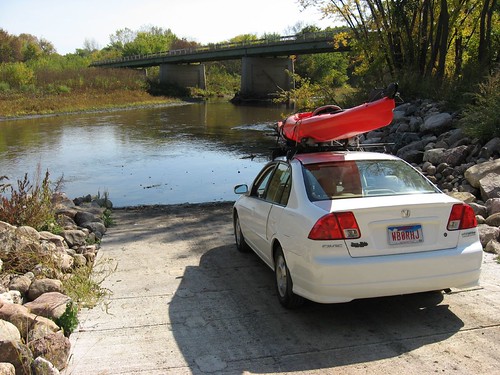
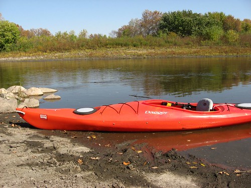
The launching point is just upstream of the highway bridge, and it is not difficult to put a kayak into the water here. Like most river spots, there is a bit of black mud on the bottom, and it is difficult to get the boat in the water without stepping in a few inches of mud. I use a pair of water sandals that I can just hose off when I get home.
I set out from the launching point about 1:00 p.m., and it was very sunny and warm. Before leaving home with my gear, I set out a frozen bottle of water to take along with me for a few sips now and then. Unfortunately, in my rush to take off, I left the bottle on the table. Since I remembered the water only when I arrived at the river, it was something that came to mind often during the paddle.
I kayaked up-stream, headed north on the river. The current was strong, but I was able to still move pretty easily up the river. Even at this point in early October, there was plenty of water in the river; the hull of my kayak did not go aground at all during the trip, although the rudder and my paddle blades scrapped bottom a few times when I strayed out of the channel. . From the launch point, I continued north on the river for an hour and ten minutes. The fall colors were vivid: shades of green, yellow, orange, and red. Some trees had lost all their leaves, while others were still full of green leaves. A wind blew through the big cottonwood trees rustling the remaining leaves. The river flows between alternating high and low banks. The high banks range from seven or eight feet to perhaps a hundred feet in height. The water depth is nearly always greater along the high banks.
About halfway through my afternoon paddle, I came across the ruins of a discontinued road and bridge - or maybe an abandoned railroad bridge. No trace of the actual bridge remains, but there are four large supporting structures in the river that supported the vanished bridge and a row of wooden stanchions that look like old telephone poles. Two of the supports are quartzite and the two middle supports are concrete. A dense log jam has developed at this point, and I had to make my way through about a ten foot gap in the debris between the two concrete supports. As always, the current quickens whenever the river narrows, and this is the only tricky spot that I found on the trip of about three miles up-stream.
The only wildlife that I observed on this stretch of the river was birds. There were three great blue heron that seemed to keep ahead of me along the entire stretch. They would fly off as I approached only to wait for me around the next bend. In addition to cormorants, there were a few other large birds that seemed like hawks in sight from time-to-time. With the regular erosion along the river, there are large tree trunks occasionally in the water as well.
This was the first time on the river that I have used a kayak equipped with a rudder, and I though that it made a great difference to my navigation, especially moving up-stream.. Normally in moving water, a kayaker has to double up on strokes along one side in order to keep a steady track in the river. With the rudder, I was able to just adjust to the effect of various currents by simply stepping on the rudder pedal, and that both increased my speed and made it possible to observe more of the shoreline and river conditions rather than fighting the current. On the way back down the river, it was just a matter of taking occasional strokes and keeping my place with rudder movements. On a kayak, the rudder has a “kick up” action that activates when the rudder strikes the bottom or some obstruction in the river.

So, while I prefer taking my kayak into lakes so that I can more closely observe the shoreline and look for wildlife or vegetation, the river is a good change of pace. It would be nice to have someone just drop you off at some point along the river and then meet you some miles downstream, but I usually have to manage my outings alone. In this case, the hard work of paddling up-stream for an hour or more is rewarded with a lazy return, just cruising along with little effort. There are many stretches of the Big Sioux that are easily accessed. The SD Department of Game, Fish, and Parks has published a pamphlet entitled “Canoeing and Kayaking in South Dakota” and a good map of the Big Sioux River. These publications would be especially helpful in arranging a shuttle or planning a trip along the river.

No comments:
Post a Comment